kind of old map vector illustration - air navigation stock illustrationskind of old map vector illustrationMap
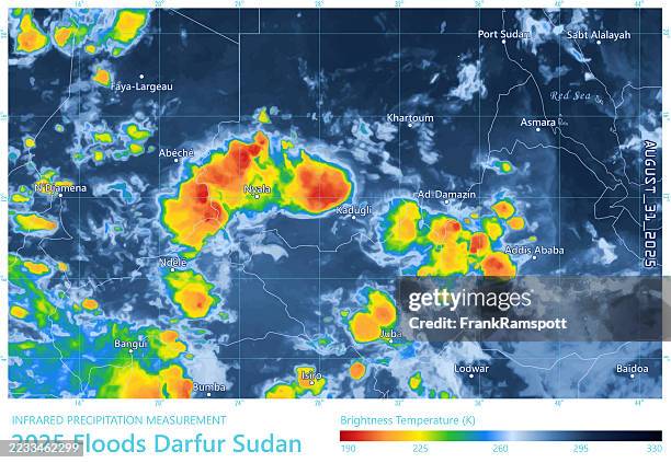
floods 20250831 precipitation map darfur sudan - air navigation stock illustrationsFloods 20250831 Precipitation Map Darfur Sudan
global warming concept flat line icons - air navigation stock illustrationsGlobal Warming Concept Flat Line IconsLogo
origami plane line icon.editable stroke - air navigation stock illustrationsOrigami plane line icon.Editable Stroke
map of united kingdom disaster icons set - air navigation stock illustrationsMap of United Kingdom Disaster Icons Set
typhoon muifa 20220911 00utc black rain map taiwan - air navigation stock illustrationsTyphoon Muifa 20220911 00UTC Black Rain Map Taiwan
paper airplane outline icons set showing multiple origami paper planes in different angles, including flying versions with dashed flight paths, minimal hand-drawn line collection for ui and print, editable stroke - air navigation stock illustrationsPaper Airplane Outline Icons set showing multiple origami paper planes in different angles, including flying versions with dashed flight paths, minimal hand-drawn line collection for UI and print, Editable StrokeLogo
hurricane idalia 20230830 06utc black rain map florida - air navigation stock illustrationsHurricane Idalia 20230830 06UTC Black Rain Map Florida
hurricane ida 20210828 precipitation map gulf of mexico - air navigation stock illustrationsHurricane Ida 20210828 Precipitation Map Gulf Of MexicoWeather Map, Radar
little super girl lifts a globe - air navigation stock illustrationsLittle Super Girl Lifts a GlobeSuperhero
cyclone amphan 2020 track northern indian ocean infographic - air navigation stock illustrationsCyclone Amphan 2020 Track Northern Indian Ocean InfographicMap
transportation icons set 2 | purple line series - air navigation stock illustrationsTransportation Icons set 2 | Purple Line series
hurricane erin 20250816 wind weather map caribbean sea infographic - air navigation stock illustrationsHurricane Erin 20250816 Wind Weather Map Caribbean Sea InfographicWeather Map, 2025
recycling and environment colorful icons set - air navigation stock illustrationsRecycling and Environment Colorful Icons Set
torrential rain 20260116 18utc precipitation map mozambique - air navigation stock illustrationsTorrential Rain 20260116 18UTC Precipitation Map MozambiqueWeather Map
freak storm 20251218 18utc precipitation map united arab emirates - air navigation stock illustrationsFreak Storm 20251218 18UTC Precipitation Map United Arab EmiratesVector, Map, Weather Map
logistic and transport infographic - air navigation stock illustrationsLogistic and Transport InfographicInfographic, Truck, Wind
camouflage rasta (red) - air navigation stock illustrationsCamouflage Rasta (Red)Jamaica, Kingston - Jamaica
hurricane patricia 2015 track eastern pacific ocean infographic - air navigation stock illustrationsHurricane Patricia 2015 Track Eastern Pacific Ocean Infographic
new energy electric vehicles and wind and solar power generation, new energy environmental protection concept map. - air navigation stock illustrationsNew energy electric vehicles and wind and solar power generation, new energy environmental protection concept map.Transportation, Car, Innovation
vector image of a flat, isolated icon compass sign - air navigation stock illustrationsVector image of a flat, isolated icon compass signLogo
typhoon haiyan 2013 track philippine sea infographic - air navigation stock illustrationsTyphoon Haiyan 2013 Track Philippine Sea InfographicMap
wildfire smoke 20260715 18utc black rain map ontario - air navigation stock illustrationsWildfire Smoke 20260715 18UTC Black Rain Map Ontario
atmospheric river 20251208 18utc precipitation map us west coast - air navigation stock illustrationsAtmospheric River 20251208 18UTC Precipitation Map US West Coast2025
typhoon shanshan 20240827 precipitation map japan - air navigation stock illustrationsTyphoon Shanshan 20240827 Precipitation Map JapanJapan, Weather Map, Map
compass navigation icons - air navigation stock illustrationsCompass Navigation IconsWind, Arrow Symbol
storm 20251117 06utc precipitation map new zealand - air navigation stock illustrationsStorm 20251117 06UTC Precipitation Map New ZealandNew Zealand, Map
storm herminia 20250126 wind weather map atlantic ocean infographic - air navigation stock illustrationsStorm Herminia 20250126 Wind Weather Map Atlantic Ocean InfographicMap, Infographic
origami black filled vector icon - air navigation stock illustrationsOrigami Black Filled Vector IconLogo, Paper, Airplane
exciting businesspeople silhouettes - air navigation stock illustrationsExciting businesspeople silhouettes
windsock icon on transparent background - air navigation stock illustrationsWindsock Icon on Transparent Background
the man searches for the sights of world travel. - air navigation stock illustrationsThe man searches for the sights of world travel.
renewable energy icon set – editable stroke vector showing solar, wind, hydro, geothermal and hydrogen power symbols representing sustainability, green technology and environmental efficiency concepts - air navigation stock illustrationsRenewable Energy Icon Set – Editable Stroke Vector Showing Solar, Wind, Hydro, Geothermal and Hydrogen Power Symbols Representing Sustainability, Green Technology and Environmental Efficiency Concepts
typhoon halong remnants 20251012 wind weather map alaska infographic - air navigation stock illustrationsTyphoon Halong Remnants 20251012 Wind Weather Map Alaska Infographic
flow, rotating lines in vertical columns pattern - air navigation stock illustrationsFlow, rotating lines in vertical columns patternWind, Pattern
cyclone alfred 20250228 precipitation map coral sea - air navigation stock illustrationsCyclone Alfred 20250228 Precipitation Map Coral SeaRadar