map of central europe - states and cities - zagreb city stock illustrationsMap of Central Europe - states and citiesMap, Serbia, Kosovo
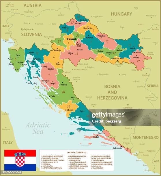
croatia - detailed map with regions, cities, country flag and infographic icons. - zagreb city stock illustrationsCroatia - Detailed map with regions, cities, country flag and infographic icons.Map, Vector, Zagreb
map of central europe - states, cities and icons - zagreb city stock illustrationsMap of Central Europe - states, cities and iconsMap, Serbia
croatia - detailed map with regions, cities and country flag. - zagreb city stock illustrationsCroatia - Detailed map with regions, cities and country flag.Zagreb, Vector
high detailed croatia map with regions and national flag - zagreb city stock illustrationsHigh detailed Croatia Map with Regions and National Flag
high detailed vintage croatia map with regions and national flag - zagreb city stock illustrationsHigh detailed Vintage Croatia Map with Regions and National FlagZagreb
croatia - detailed map with regions and cities. set of flags, globe, country outline, country location on world map. - zagreb city stock illustrationsCroatia - Detailed Map with Regions and Cities. Set of Flags, Globe, Country Outline, Country Location on World Map.Map, Illustration
croatia detailed map with regions and cities of the country. - zagreb city stock illustrationsCroatia detailed map with regions and cities of the country.Island, Zagreb
map of croatia. political map with regions, national flag, geographical borders of montenegro, hungary, slovenia, serbia and italy - zagreb city stock illustrationsMap of Croatia. Political Map with Regions, National Flag, Geographical Borders of Montenegro, Hungary, Slovenia, Serbia and Italy
croatia - detailed map with regions and cities. set of flags, globe, country outline, country location on world map. - zagreb city stock illustrationsCroatia - Detailed Map with Regions and Cities. Set of Flags, Globe, Country Outline, Country Location on World Map.
map of croatia - states, cities, flag, navigation icons - zagreb city stock illustrationsMap of Croatia - states, cities, flag, navigation icons
zagreb cathedral, croatia, wood engraving, published in 1893 - zagreb city stock illustrationsZagreb Cathedral, Croatia, wood engraving, published in 1893
croatia detailed map with regions and cities of the country. - zagreb city stock illustrationsCroatia detailed map with regions and cities of the country.
croatia - detailed political map of the country featuring major cities, capitals, bodies of water, and a set of navigational symbols. retro-style vector design. - zagreb city stock illustrationsCroatia - detailed political map of the country featuring major cities, capitals, bodies of water, and a set of navigational symbols. Retro-style vector design.
map of central balkan region - states, cities and icons - zagreb city stock illustrationsMap of Central Balkan Region - states, cities and icons
croatia - detailed map with regions and cities of the country. - zagreb city stock illustrationsCroatia - detailed map with regions and cities of the country.
croatia - detailed political map showing regions, cities, and bodies of water. - zagreb city stock illustrationsCroatia - Detailed political map showing regions, cities, and bodies of water.
green map of central balkan region - states and cities - zagreb city stock illustrationsGreen Map of Central Balkan Region - states and citiesKosovo, Map
green map of central balkan region - zagreb city stock illustrationsGreen Map of Central Balkan Region
croatia green map with regions and navigation icons - zagreb city stock illustrationsCroatia Green Map with Regions and Navigation IconsIcon Symbol
croatia - detailed administrative map with regions, rivers, cities and national flag. - zagreb city stock illustrationsCroatia - Detailed administrative map with regions, rivers, cities and national flag.
croatia - detailed map with regions and cities of the country. - zagreb city stock illustrationsCroatia - detailed map with regions and cities of the country.Map, Illustration
map of central balkan region - states and cities - zagreb city stock illustrationsMap of Central Balkan Region - states and cities
map of croatia - states, cities and flag - zagreb city stock illustrationsMap of Croatia - states, cities and flag
green map of central europe - states and cities - zagreb city stock illustrationsGreen Map of Central Europe - states and citiesHungary, World Map, Austria
map of croatia. political map with regions, national flag, geographical borders of bosnia and herzegovina, serbia, slovenia, italy, austria and hungary - zagreb city stock illustrationsMap of Croatia. Political Map with Regions, National Flag, Geographical Borders of Bosnia and Herzegovina, Serbia, Slovenia, Italy, Austria and HungaryMap, Icon Symbol
croatia vector map with regions, lakes, rivers, national flag and geographical borders - zagreb city stock illustrationsCroatia Vector Map with Regions, Lakes, Rivers, National flag and Geographical Borders
vintage croatia map with regions, national flag and geographical borders. vector illustration - zagreb city stock illustrationsVintage Croatia Map with Regions, National flag and Geographical Borders. Vector Illustration
map of croatia. political map with regions, national flag, geographical borders of montenegro, hungary, slovenia, serbia and italy - zagreb city stock illustrationsMap of Croatia. Political Map with Regions, National Flag, Geographical Borders of Montenegro, Hungary, Slovenia, Serbia and Italy
croatia map with national flag. vector blue illustration with regions, geographical borders and capital cities - zagreb city stock illustrationsCroatia Map with National Flag. Vector Blue Illustration with Regions, Geographical Borders and Capital Cities
vintage croatia map with regions, lakes, rivers, national flag and geographical borders. vector illustration - zagreb city stock illustrationsVintage Croatia Map with Regions, Lakes, Rivers, National flag and Geographical Borders. Vector Illustration
croatia map with regions, navigation icons and national flag. file contains editable separated regions - zagreb city stock illustrationsCroatia Map with Regions, Navigation Icons and National Flag. File contains Editable Separated Regions
map of croatia. political map with regions, national flag, geographical borders of bosnia and herzegovina, serbia, slovenia, italy, austria and hungary - zagreb city stock illustrationsMap of Croatia. Political Map with Regions, National Flag, Geographical Borders of Bosnia and Herzegovina, Serbia, Slovenia, Italy, Austria and Hungary
croatia map with regions, capital cities and national flag - zagreb city stock illustrationsCroatia Map with Regions, Capital Cities and National flag
croatia map. vintage illustration with regions and national flag - zagreb city stock illustrationsCroatia Map. Vintage Illustration with Regions and National Flag
map of croatia. political map with regions, national flag, geographical borders of montenegro, hungary, slovenia, serbia and italy - zagreb city stock illustrationsMap of Croatia. Political Map with Regions, National Flag, Geographical Borders of Montenegro, Hungary, Slovenia, Serbia and Italy
croatia map with national flag. vector illustration with regions, navigation icons and capital cities - zagreb city stock illustrationsCroatia Map with National Flag. Vector Illustration with Regions, Navigation Icons and Capital Cities
croatia - detailed map with regions and cities of the country. - zagreb city stock illustrationsCroatia - detailed map with regions and cities of the country.
croatia - green highly detailed map - zagreb city stock illustrationsCroatia - green highly detailed map
croatia map. vintage illustration with regions and national flag - zagreb city stock illustrationsCroatia Map. Vintage Illustration with Regions and National Flag
croatia vector map with regions, lakes, rivers, national flag and geographical borders - zagreb city stock illustrationsCroatia Vector Map with Regions, Lakes, Rivers, National flag and Geographical Borders
croatia map with regions, navigation icons and national flag - zagreb city stock illustrationsCroatia Map with Regions, Navigation Icons and National flag
map of central europe - states, cities, navigation icons - zagreb city stock illustrationsMap of Central Europe - states, cities, navigation iconsMap
map of central balkan region - states, cities, navigation icons - zagreb city stock illustrationsMap of Central Balkan Region - states, cities, navigation icons
croatia map with regions and national flag. vector illustration - zagreb city stock illustrationsCroatia Map with Regions and National Flag. Vector Illustration