map of the word with lines marking boundaries of tectonic plates - plate tectonics map stock illustrationsMap of the Word with lines marking boundaries of tectonic platesTectonic, Plate Tectonics
illustration of a world map showing a future scenario, with australia having moved much further to the north, and north america having split away from south america - plate tectonics map stock illustrationsIllustration of a world map showing a future scenario, with Australia having moved much further to the north, and North America having split away from South AmericaPlate Tectonics, Motion, Map
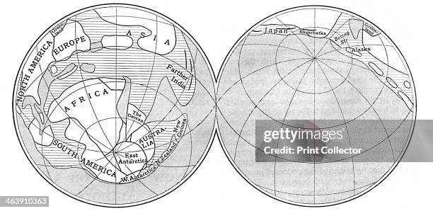
Diagram of the Earth during the Carboniferous period, 1922. Land is represented by the unshaded areas, deep sea by the areas shaded with diagonal...Diagram of the Earth during the Carboniferous period, 1922.Plate Tectonics
Model map of volcanoes at Timanfaya Volcano Interpretation and Visitors' Centre, Lanzarote, Canary Islands, Spain.Model map of volcanoes at Timanfaya Volcano Interpretation and Visitors' CentrePlate Tectonics
close-up of a globe - plate tectonics map stock pictures, royalty-free photos & imagesClose-up of a globe
Map showing tsunamis since 2004 along the Pacific "Ring of Fire", an area of tectonic plates joints known for earthquakes and volcanic eruptions.TSUNAMI-INDONESIA-VOLCANO-DISASTER
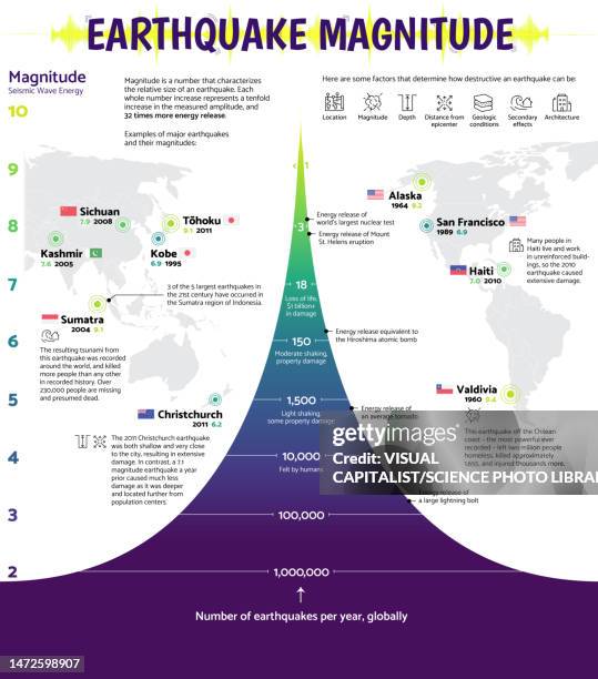
power and frequency of earthquakes, infographic graph - plate tectonics map stock pictures, royalty-free photos & imagesPower and frequency of earthquakes, infographic graphEarthquake, Map, Richter Scale
illustration of the supercontinent pangaea - plate tectonics map stock illustrationsIllustration of the supercontinent PangaeaPlate Tectonics
illustration of world map showing constructive plate margins and destructive plate margins - plate tectonics map stock illustrationsIllustration of world map showing constructive plate margins and destructive plate marginsFault - Geology, World Map, Map
One of a selection of 44 scientific teaching diagrams, drawn and engraved by John Emslie on geology, geography, astronomy and natural philosophy with...Popular Geology, 1 October 1860.Earth's Crust
Theory of Continental Drift, 1922. Diagram from an article by Alfred Wegener on his theory of Continental Drift, published in Discovery, London,...Theory of Continental Drift, 1922.Map, Germany, Eocene Age
Map showing the the Pacific Ring of Fire, a zone of strong seismic and volcanic activity. Mexico City was hit by a 7.1 magnitude earthquake on...QUAKE-MEXICO
Map of southern Europe showing the risk of earthquakes and the main tectonic plates and their movements.GREECE-EARTHQUAKE-quake
Map of southern Europe showing the risk of earthquakes and the main tectonic plates and their movements.CROATIA-EARTHQUAKE
Map of Europe showing the risk of earthquakes and the main tectonic plates and their movements.GREECE-QUAKE
Map showing tsunamis since 2004 along the Pacific "Ring of Fire", an area of tectonic plates joints known for earthquakes and volcanic eruptions.CORRECTION / TSUNAMI-INDONESIA-VOLCANO-DISASTER
satellite view of tahiti. - plate tectonics map stock pictures, royalty-free photos & imagesSatellite view of Tahiti.Topography, Tahiti, French Overseas Territory
satellite view of kamchatka peninsula, eastern russia. - plate tectonics map stock pictures, royalty-free photos & imagesSatellite view of Kamchatka Peninsula, Eastern Russia.
illustration of movement of continents in prehistoric times - plate tectonics map stock illustrationsIllustration of movement of continents in prehistoric times
illustration of three globes and development of continents, 200 million years ago, 50 million years ago, and present day - plate tectonics map stock illustrationsIllustration of three globes and development of continents, 200 million years ago, 50 million years ago, and present day