old torn atlas map of eurasia - ussr map stock pictures, royalty-free photos & imagesOld Torn Atlas Map of EurasiaRussia, Eurasia, China - East Asia
General Map of Saint Petersburg Province: Showing Postal and Major Roads, Stations and the Distance in Versts between Them, 1820. This 1820 map of...General Map Of Saint Petersburg Province: Showing Postal And Major Roads
moscow, russia vector map - ussr map stock illustrationsMoscow, Russia Vector MapMap, Moscow - Russia, Former Soviet Union
Political and Administrative map of the USSR. 1973.Political and Administrative map of the USSR.Map, Former Soviet Union, Cold War
old map of europe - ussr map stock pictures, royalty-free photos & imagesold map of EuropeMap, Former Soviet Union, Old-fashioned
map of asia 1942 - ussr map stock pictures, royalty-free photos & imagesMap of Asia 1942Map, World Map, Pacific Ocean
Map of the Soviet Union indicating the states that constitute it and their year of accession from 1917 to 30 December 1922: ACCP = autonomous...Map Of USSRMap, Former Soviet Union, Russia
vector map of russia and flag - ussr map stock illustrationsVector Map of Russia and FlagMap, Former Soviet Union
russian federation - detailed map with regions and cities of the country. - ussr map stock illustrationsRussian Federation - detailed map with regions and cities of the country.Former Soviet Union, Russia, Map
russian federation - detailed administrative map with regions, rivers, cities and national flag. - ussr map stock illustrationsRussian Federation - Detailed administrative map with regions, rivers, cities and national flag.
russia simple blue map on white background - ussr map stock illustrationsRussia simple blue map on white backgroundRussia, Map, Crimea
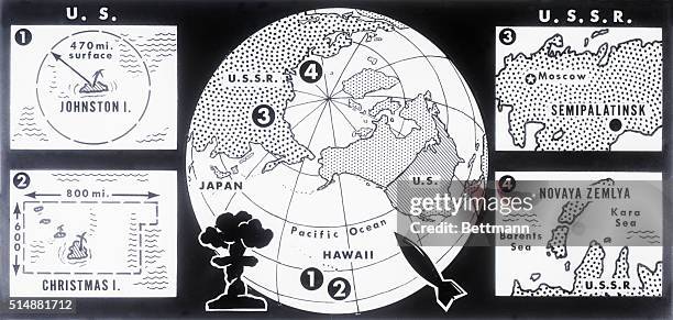
News charts show the sites of a series of 1962 nuclear tests by the United States and the Soviet Union. Over Johnston Island and Christmas Island in...Sites of US and Soviet Atomic TestsFormer Soviet Union, Island, Bomb
antique french map of russia - ussr map stock illustrationsAntique French map of RussiaFormer Soviet Union, Map
russian federation detailed map with regions and cities of the country. - ussr map stock illustrationsRussian Federation detailed map with regions and cities of the country.Map, Russia, Eurasia
This map shows the Soviet Union and Red China, who resumed top level relations 11/24. Such relations were suspended four years ago. In addition, the...Map Showing Russia and China with Other CountriesMap, Former Soviet Union, No People
Map of the Far East of the USSR, Northern China and Mongolia, 1930. This Soviet-era map is intended to serve a propaganda purpose. On the top and...Map Of The Far East Of The Ussr
Map of Eastern U.S.S.R. Missile Bases', by Andy Warhol . American artist who was a leading figure in the visual art movement known as pop art.Map of Eastern U.S.S.R. Missile Bases.Map, Former Soviet Union, Communism
Berlin Blockade Map 1948. The Berlin Blockade was one of the first major international crises of the Cold War. During the multinational occupation of...Berlin Blockade Map.Map, Berlin Blockade, Berlin
Map of Poland with the capital, Warsaw, and major cities and bordering countries shown, including East Germany, Czechoslovakia, USSR and the Baltic...Color Map of PolandFormer Soviet Union, Map, East Germany
World War II scout for the Red Army points out important information on his map while his detachment commander observes.Russian Soldier Reporting Results of Scouting MissionRussia, World War II
Map of the evolution of the Russian sphere of influence after the fall of the USSR in 1991RUSSIA-UKRAINE-POLITICS-USSR-HISTORY-COMMUNISM-diplomacy
The Russian discoveries from the map published by the Imperial Academy of St. Petersburg, 1775. This map, showing the known geography of Alaska in...The Russian Discoveries From The Map Published By The Imperial Academy Of St. Petersburg
Smotri! Bogatstva Sovetskii Respublik zhdut napora truda!, c1921. [Place: Odessa] Additional Title: Ukrainian -Look the Treasures of Soviet Republic...Smotri! Bogatstva Sovetskii Respublik Zhdut Napora Truda!
Russian political map of the World 1980.Russian (Soviet) political map of the World 19801980, Former Soviet Union, World Map
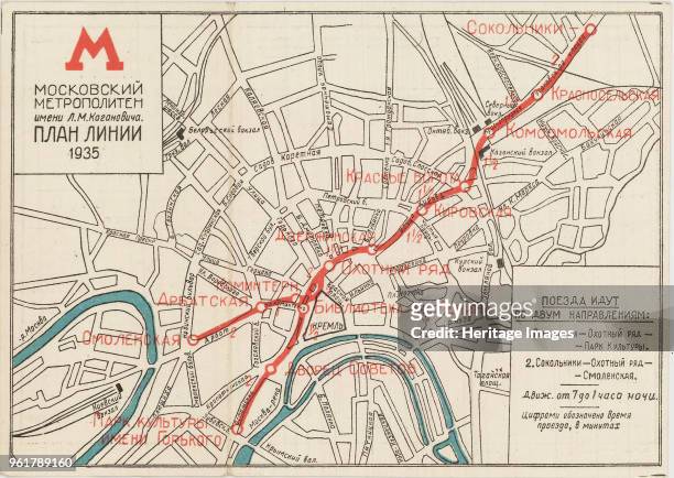
The first map of the Moscow subway, opened on May 15 1935. Private Collection.The First Map Of The Moscow SubwayMap, Subway, Moscow - Russia
Man points to the orbital path of the Mir space station on a world map, at Mir mission control in Kaliningrad.Map of Mir in OrbitMir Space Station
Russian Officers Looking at a MapRussian Officers Looking at a MapMap, Former Soviet Union, Moscow - Russia
The Five-Year Plan of New Construction of Industry of the USSR: Map of the Asiatic Part of the USSR, 1930. Supplement to the map of the Five-Year...The Five-Year Plan Of New Construction Of Industry Of The Ussr: Map Of The Asiatic Part...
Map showing conquests by soviets. October 1917Map showing conquests by soviets.Former Soviet Union, Map
map of russia - states, cities, flag, navigation icons - ussr map stock illustrationsMap of Russia - states, cities, flag, navigation iconsMap, Russia, Kursk - Russia
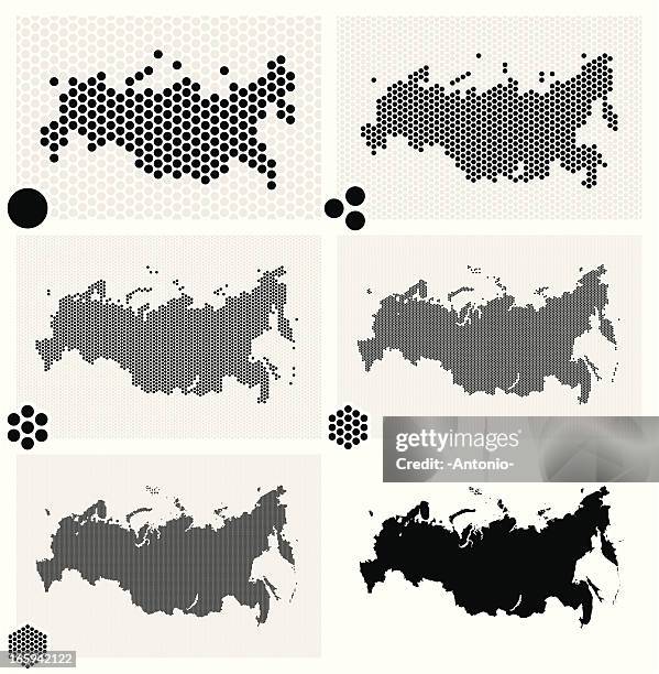
dotted maps of russia in different resolutions - ussr map stock illustrationsDotted maps of Russia in different resolutionsRussia, Map, Abstract
Karte des Deutschen Reichs mit denGrenzen von 1937: Aufteilung inBesatzungszonen nach Massgabe derBerliner Erklärung vom ;einschliesslich der...Deutschland ab 1945 - Karte des Deutschen Reichs mit den Grenzen von 1937Map, Former Soviet Union
Russian map showing the extent of the armed struggle in the Second World War 1939-1945.The scale of the armed struggle in the Second World War 1939-1945Map, World War II, 1940-1949
President Reagan points at a map of the Soviet Union as he speaks to listeners about the need to control nuclear missiles.Ronald Reagan With Map of Soviet UnionRonald Reagan - US President, Nuclear Weapon, Missile
dotted maps of russia in different resolutions - ussr map stock illustrationsDotted maps of Russia in different resolutionsMap, Russia, Former Soviet Union
This map of Russia and surrounding countries highlights Hitler's campaign in Russia, where Germans eventually retreated on nearly all fronts.Map of Nazi Invasion in Russia Going AwryCaspian Sea, Russia, Nazism
map of russia - states, cities and flag - ussr map stock illustrationsMap of Russia - states, cities and flagMap, Former Soviet Union, Russia
Black and white photograph of World War II ; map of the German offensive in Russia that was deployed fro the Arctic to the North Sea, end of July...Maps of the German invasion of RussiaMap, Russia, Former Soviet Union
'The Crusade against Bolshevism', Vichy French propaganda poster, 1941. Map depicting the Nazi invasion of the Soviet Union, Operation Barbarossa,...'The Crusade against Bolshevism', Vichy French propaganda poster, 1941.Former Soviet Union, 1940-1949, Map
Plan of New Moscow, 1923. Private Collection. Creator: Shchusev, Alexey Viktorovich .Plan Of New Moscow
map of eastern hemisphere highlighting the soviet union - ussr map stock pictures, royalty-free photos & imagesMap of Eastern hemisphere highlighting the Soviet UnionFormer Soviet Union, Map
Illustrated map of Russia with icons of culture and history. Circa 1950sVisit the USSR, Intouist Travel PosterMap, Former Soviet Union, Tourism
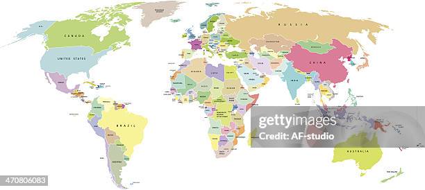
political map of the world - ussr map stock illustrationsPolitical Map of The WorldNorth America, Former Soviet Union, Map
grey plain map of russia on white background - ussr map stock illustrationsGrey plain map of Russia on white backgroundMap, Former Soviet Union, Geographical Border
Map of the evolution of the Russian sphere of influence after the fall of the USSR in 1991RUSSIA-POLITICS-USSR-ANNIVERSARY-HISTORY-COMMUNISM
Extraction and primary processing of non-metallic minerals as of January 1 1934. From the atlas "Industry of the USSR at the beginning of the 2nd...Extraction And Primary Processing Of Non-Metallic Minerals As Of January 1
Coal industry on January 1 1934. From the atlas "Industry of the USSR at the beginning of the 2nd Five-Year Plan. Geographical atlas." Conventional...Coal Industry On January 1